
Tags
Changbaishan, DPRK, Jilin, Long White Mountain, North Korea border, travels in China, Wanda Resort
1442 steps to the top of the mountain!
 Today is day twenty-one of my travels around parts of China and thankfully I purchased a VPN otherwise I would not have access to my Gmail/Google or WordPress as China has completely blocked all access. So this wonderful VPN allows me to post on my blog.
About a week ago I was visiting Jilin which is a province in the north/west of China and borders DPRK (North Korea). I had wanted to visit Changbaishan which is the tallest mountain peak in North China and runs through three Chinese provinces including Jilin and to the border of DPRK.

(map courtesy of internet)
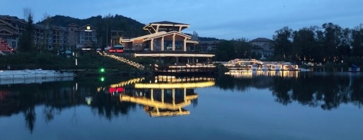
After a couple of days in Changchun (the capital of Jilin) with our tour guide, my friend and I drove nearly five hours to reach our location at a ski resort in Changbaishan. Parts of this resort were a little kitschy but the hotel was lovely (and bed comfy not like usual Chinese beds ie hard as bricks). After we settled in, we went for a walk around the man-made lake looking at the ‘interesting’ blow up bears, which I still have no idea why there are there!! The lake area was rather lovely at night and I managed to capture a couple of nice photos.
 We did enjoy a great Chinese dinner at a nearby restaurant. Spicy tofu, eggplant [not great looking in my photo but absolutely delicious) and fried potatoes – probably not all that healthy but as it was our only meal of the day we thoroughly enjoyed it.


So off we trudge up these steps with a reminder every 100 steps how far you had walked (or how far you had to walk depending on whether you are glass half full type of person; on this day I was not).
 And a sign stating the obvious!
 I must say though that the views back down the mountain were pretty special.
 Along the way there are very fit [old] Chinese men waiting near a small carriage and for a huge fee you can be carried up to the top like an Emperor…but we chose to walk.
 We took lots of breaks along the way and then finally arrived having chatted to a South Korean film crew along the way who asked for an interview at the top. I told them if I can breath when I arrived, I would partake in an interview.
As I mentioned Lake Tianchi is at the top and it was definitely worth the climb. Our guide told us that many people don’t get to see the lake because the fog is thick on most days. Fortunately for us we had full views of the lake and surrounding mountains.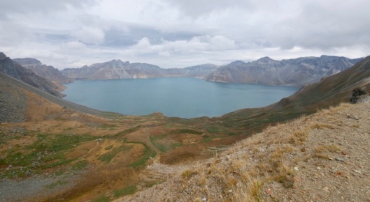
 And without the fog we also were able to see the China and North Korea 37 boundary marker along with the dividing mountains of China and North Korea on the North Korean side.

 It was then time for my interview with the South Korean film crew, shame I had windswept hair [but not in a good way]…


 At the base of the mountain we stopped off and walked around the national park [more on that later], then two more buses to get back to our hotel where I collapsed!!

Technology is wonderful. With the VPN, what was the internet speed like for blogging? Will we see the ROK TV interview in Australia?
As always great story and great photographs Sue.
LikeLiked by 1 person
What a wonderful day out Sue. It was certainly worth the effort to climb all those steps to be rewarded with such fine views. How exciting that you were filmed for South Korean TV, hope we will be able to view a podcast !
LikeLiked by 1 person
This just shows again how huge China is and how little I have visited thus far!
But how interesting about the interview, I guess I’d be too exhausted after such long hike
LikeLiked by 1 person
That was sure quite a climb, but glad the view at the top was worth it. What a fascinating place.
LikeLiked by 1 person
Hey thanks Gaz. Don’t think I the interview will be in Aust. They live and work in Beijing so guess it will be in BJ or South Korea. Internet speed is pretty good. Does drop out regularly but can reconnect pretty quickly and only $16 for the month I am here so very happy.
LikeLiked by 1 person
I feel tired just thinking about those stairs!!! wahahah Looks amazing, Sue~~~
LikeLiked by 1 person
Wow, that Internet cost is pretty good. Australia is so expensive.
I hope you get good feedback from the interview.
LikeLiked by 1 person
A lovely read Sue! Good to be introduced to Jiling. I moved from Shanghai to Oslo when I was 16. Have only been to a few places in China. Great you made to the top and gave an interview. What an adventure!
LikeLiked by 1 person
It was a great day out Marion definitely- so worth the climb.
LikeLiked by 1 person
It is a huge place isn’t it. So much to see.
LikeLiked by 1 person
Thanks Mavis.
LikeLike
Thanks Joyce. My calves were very sore for three days. I am so unfit!!!
LikeLiked by 1 person
Thanks G.
LikeLiked by 1 person
Thanks Isabelle. I am sure you would see incredible changes to Shanghai now.
LikeLiked by 1 person
Ouch. Well, it was a big hike.
LikeLiked by 1 person
What a day! And I didn’t expect the landscape to be like this. Doesn’t it look like Scotland in a way? I had no idea a dormant volcano could be visited in China, thanks for informing about that!
LikeLiked by 1 person
Fascinating!
LikeLiked by 1 person
Love your photos, this inspires me to want to take a trip!
LikeLiked by 1 person
Thanks John.
LikeLike
Thank yo very much. I hope you do.
LikeLike
Thanks for the photos and sharing your tour. The furthest north I’ve been is Harbin, and they had firm beds and sand pillows. Where can we see your interview?
LikeLiked by 1 person
The stairway looks pretty challenging. Fabulous photos of the landscape, Sue!
LikeLiked by 1 person
Thank you very much Amy I had sore calves for two days afterwards. Ha ha.
LikeLike
Yes just love those hard beds…slept on one last night. Grr. I have no idea how to find it the interview sorry. I didn’t ask.
LikeLike
Amazing!Those views are gorgeous.
LikeLiked by 1 person
Thank you so much much!!!!
LikeLiked by 1 person
I guess foreigners are quite a rare sight in that remote place, so I’m sure the film crew was happy to have you as an interview partner 😉 The views are absolutely unique and stunning!
LikeLiked by 1 person
Thank you again. It was worth the 1442 steps but really don’t like climbing.
LikeLike
You did it and was rewarded with fantastic vistas. Congrats!
LikeLiked by 1 person
Thanks so much again. I was really glad I persevered.
LikeLiked by 1 person
Wow this is beautiful! Great photos!! 🙂
LikeLiked by 1 person
Thanks very much Rachel.
LikeLike
Your lake view reflection photos could be in magazines! 🌟
LikeLiked by 1 person
Thank you again. It’s funny I loved that photo too and it’s only taken with my phone.
LikeLike
I appreciate your sharing parts of the world I may not get to visit, so when you use your phone, it is fine with me! 😊
LikeLiked by 1 person
How lovely. Thank you.
LikeLike